
What is geocoding
Geocoding is the computational process of converting a physical address description to a location on the Earth’s surface (spatial representation in numerical coordinates). Geocoding relies on a computer representation of address points, the road network with postal and administrative boundaries. The geographic coordinates that represent locations usually differ widely in positional accuracy. Examples include building centroids, land parcel centroids, interpolated locations based on thoroughfare ranges, street segments centroids, postal code centroids (e.g. ZIP codes, CEDEX), and Administrative division Centroids.
What is API
When you use a program on your computer, the program connects to the Internet and transmits data to a server. The server then retrieves that data, interprets it, performs the required actions and transfers it back to your computer. The program then interprets that data and presents you with the information you wanted in a readable way. This is what API entails.
API Also Provides Is a Layer of Security. Your phone’s or computer’s data is never fully exposed to the server, and in return the server is never fully exposed to your phone or computer. Instead, each communicates with small packets of data, sharing only that which is necessary. APIs have become so valuable that they make up a huge part of the revenue of many businesses. Geocode API adheres to standards and is user-friendly, easily accessible and understood broadly.
Function of Geocode APi
Geocode API allows you several uses. From simple data analysis to business and customer management to distribution techniques because there is a wide range of applications for which geocoding can be used. With geocoded addresses, you can recognize patterns within the information. You can also display your address information based on certain parameters, allowing you to further analyze the information. You can geocode by entering one location description at a time or by providing many of them at once in a table. Geocoding allows you to readily find various categories of location.
You can use Geocode API as a crucial part of your customer data management. Almost all organizations maintain address information for each customer or client. This is usually in the form of a table, containing the customer’s name, address, buying trends, and other information you have collected. Geocode API creates a way for you to harvest your customers’ information and create a map of their locations. Using a variety of related applications, you can use this information in many ways, from establishing marketing strategies to targeting specific clusters of customers to producing route maps and directions. The geocoded locations of your customers can be very useful data.
With Geocode API, you can make use of varied methods to share your geocoding functionality. These include everything from collecting the address locators and sharing via a compressed file or compact disc to developing an online application, which allows users to do geocoding over the Internet. Many real estate firms have found advantages in distributing information about available real estate via the Internet through Geocode API. By combining the database of available homes, you can distribute the spatial and nonspatial information about a home to a wide audience.
Why Geocode API is my go to
- Speed
When it comes to speed, we all know computers are very fast. They are built so that they can perform tasks like geocoding, because they work faster and more efficiently than we can. Once you subtract incidentals like connection sped and substandard hardware, we really are what slows computers down. We impose a lot of limitations on our computers that prevent them from running at peak capacity. With Geocode API you can let them do the work automatically for you. Geocode API has systems built to handle large numbers of requests and thus are not afraid to allow we customers to turn on the fire hose. Whether you are baking 1,000, 10,000 or 100,000 cookies, having a large capacity helps. Geocode API’s increased capacity means it is able to process more requests simultaneously. Turnover time is remarkably short and any queueing that has to happen, moves speedily.
- Accuracy and reliability
I must commend Geocode API’s accuracy and reliability. From my experience with different providers, I must say that I notice a lot of lapses in precision. Not all geocodes are the same and some will take you to the wrong address’ doorstep. Uptime is a metric used to measure how long and how consistently a system has been ‘up’ and running. It is a way to know if you should be worried whether the service won’t be functioning when you need it. It is something you just can’t compromise on.
- Scalability
Geocode API is highly scalable. In case you do not understand the concept of scalability and why it is important to you –
Broadly speaking, scalability can be defined as being extensible, built into architecture and implies demand balancing. Scalable software like Geocode API is extensible at the most basic level. The design itself does not limit functionality, and instead allows multiple avenues to tie into the underlying services and systems to enable extensions and other services. By saying it is built into architecture, scalability is imbued into the foundational stages of the Geocode API itself. To put it simply, it is built for scalability from the onset.
Scalability also implies demand balancing. Just as important as extensibility is responding to demand. Geocode API ensures that the handling of traffic is done just as well with one hundred requests as with one million — it is implied in the name, “scale.” The serious implication is that scalability naturally demands efficient performance, regardless of technique or methodology, at both extremely high traffic and extremely low traffic.
- Fair pricing and excellent customer service
Geocode API offers fair pricing which means you are not forced into paying for bulky services you do not need. You have the opportunity to choose between their free or custom plans and let their servers do the work. They bill you monthly and all contracts can be canceled, upgraded or downgraded whenever you want. They are also staffed by a wonderful customer service which presents premium support. Anytime I had to contact them, I was replied within one business day. They provide excellent integration support for Geocode software and all I had to do was reach out via E-mail.
If you want to enhance the user experience of your website or application by providing a fast and reliable location input field with auto completion you really need to hop on Geocode API. You get 3000 free requests each day and there are no throttling or rate limits. One-time or occasional users may be able to get away with an unreliable service but for recurring customers like myself, some assurance of reliability is needed.
Geocode API gives this assurance in the form of a Service Level Agreement. It promises uptime that meets far-reaching thresholds.
A lot of providers don’t make this commitment. If you are a regular user of geocoding services, then you should opt for a service that guarantees it won’t go out on you and then upholds that promise. In conclusion, you want Geocode API.


 ZeroSSL Review – SSL Protection for All
  RankTrackify- Seamlessly check and track your keyword rankings
 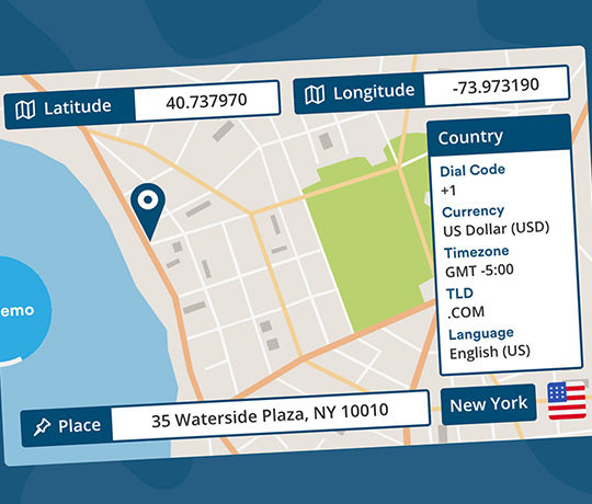 PositionStack API Review
  Aviationstack API Review
 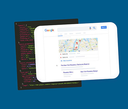 SERPStack Review